


Understanding the Critical Role of ALTA/ACSM Title Surveys
At Brigen Consulting, we understand that the American Land Title Association (ALTA) survey plays a significant role in the civil engineering field. The ALTA survey combines details extracted from boundary and landscape surveys, along with easement and title information. This integrated approach helps in shaping commercial land transactions and protecting insuring title agencies from exceptions to the title. Our mission is to provide in-depth ALTA surveys that assure the integrity of your commercial land dealings.
Delving into the Essence of ALTA Surveys
ALTA surveys visually represent a property's features and potential issues, such as flood plains, oversteps, access, and right-of-way. They clearly highlight areas of land that can be used, considering zoning and building set-backs, making them a key tool in site and land development.
What Sets Brigen Consulting Apart
At Brigen Consulting, we adopt a hands-on approach to deliver comprehensive on-site fieldwork. Our range of services encompasses managing easements, servitudes, right of way, access, and a complete title report review. We understand the importance of accurate mapping; hence, we prepare a plat or map that mirrors the results of the fieldwork and its relationship to pertinent documents.
Unraveling the Complexities of ALTA Surveys
To understand a Land Title Survey, you need to know how land ownership works and why title insurance is important. An ALTA survey provides a thorough review and evaluation of important elements such as boundary locations, ownership lines, rights of way, and easements within and near a particular property or piece of real estate.

Why ALTA/ALSM Matters?
The process of land survey drafting incorporates the exteriors or centerlines of record easements, evidence pointing to the possibility of prescription or limitation rights, and visible improvements on the site. A Land Title Survey is an effective method to identify such lines or edges for proper description and documentation.
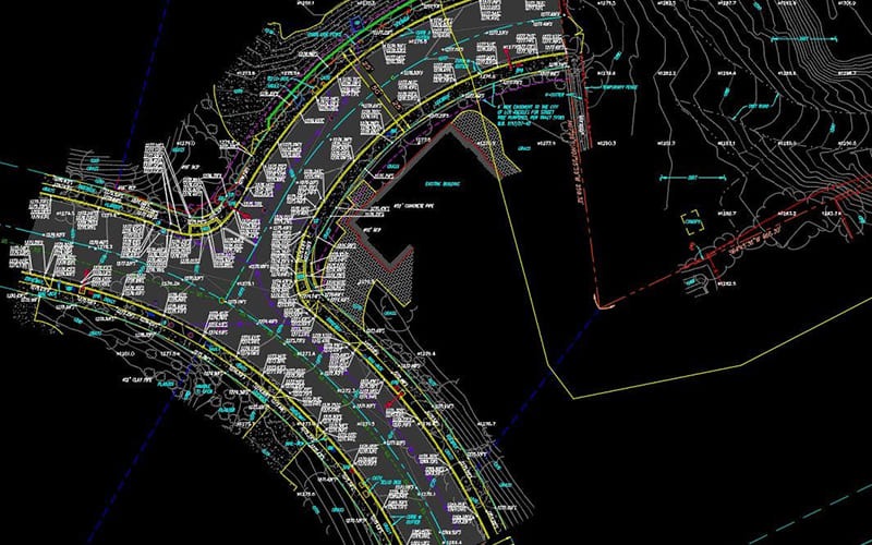
Breaking Down the Elements of ALTA Land Title Survey
An ALTA land title survey incorporates several critical components. Usually, after identifying the property through any additional axes, we draw a plat map, a scale representation of a land area subdivided into blocks with lanes, alleys, and so forth. In contrast, a title search involves investigating public registry documents to ensure the property title's security.
Additionally, we mark the Set Back Building Line, which shows how far from an edge, property line, or structure construction must stay. The Right of Way is an area of land granted by agreement for construction according to delegated management.
Excelling in CAD Drafting for ALTA Surveys
At Brigen Consulting, we take pride in offering premium, cost-effective CAD drafting services for ALTA Surveying operations. Our team of experts uses the latest technology to deliver high-quality and precise drafting. We hold extensive experience in creating Land Survey drawings for ALTA surveying operations and other services.

Choosing Brigen Consulting for Your ALTA Surveying Needs
Put your trust in Brigen Consulting for all your ALTA Surveying needs. We provide comprehensive CAD drafting services that result in efficient outsourcing solutions. For more information or to request a quote for your project, feel free to contact us. With us, you are choosing a reliable, dedicated, and expert service that understands the nuances of ALTA surveying.


